- Departments & Services
- Your Government
- Our Community
-
How Do I?
-
- Search the Website Apply for a Job Apply for an Advisory Committee Contact the City File a Public Records Request
- Find City Codes Find Planning & Zoning Get a Police Report Get a Business License Get a Building Permit
- Pay My Water Bill Report a Nuisance Start Water Service Submit a Complaint Find Forms Pay My Court Fine
-
Coburg Loop Path
The City of Coburg received a grant from the State of Oregon Transportation & Growth Management Program in 2008 to develop a strategy for the creation of a hard surfaced bicycle and pedestrian path that will connect key areas in town in a loop system.
The strategy was developed between January 2008 and June 2009. The path will enhance the livability of Coburg by providing a car-free mobility option and greatly enhance the safety for those walking and bicycling by creating connections between Coburg’s neighborhoods, downtown, parks, school, and employment areas. Learn about the project here.
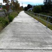
The first segment of the Coburg Loop was completed July 2013 and is located on the westside of South Coburg Industrial Way (along the eastside of Muddy Creek Irrigation Channel near Truck N' Travel). This project was funded by the State of Oregon as part of the Coburg/I-5 Interchange Improvement Project.
The next segment was completed in early 2018 and is along the westside of North Coburg Industrial Way and turns west, crossing Muddy Creek and connects to Jacob Spores Park and the residential streets of Sarah Lane and Shane Court. It was funded with Federal funds through the Central Lane Metropolitan Planning Organization. A local match of 10.27% was helped to be met through a land donation by adjacent property owners.
The third segment was completed in late 2018 and is in the northwest section of town, beginning at the intersection of Coburg Rd./Van Duyn Rd./N Coburg Rd./S Bottom Lp. and provided bike and pedestrian crossing improvements as well as a path that heads south and east along the existing bioswale; a popular walking route. The end of this segment of the path will be at the intersection of Water Street and Van Duyn Rd. This project was funded through the Oregon State "Enhancement" funds. A local match of 10.27% was met through Parks System Development Charges funds.
A fourth segment is in the design phase which starts from the "bend" in segment 2 and heads north along the west side of N Coburg Industrial Way. The path encompasses a privately built section and eventually connects to the Trails End Park. A local math of 10.27% is being met through a land donation and Parks System Development Charges funds.
Click any thumbnail image to view a slideshow